|
|
|
|
|
|
|
3rd Feb. 2002 This was my second trek of the year 2002. I went with Sahyagiri this time. There were three other members namely Makarand & his wife, Mandar. We gathered at Borivali st. early morning at around 6:00am. Took our ticket till Palghar, then via Virar local & then Shuttle till Palghar reached at around 8:45am. After breakfast we started at around 9:00am to reach the destination. The fort can easily identified from the Railway station towards east. We wallked almost 12 kms via Nevli Pada(2 km), then Bhagola(3km) & till top. The forest is not that dense. You will find two types of flower especially a fresh Orange coloured palate(3 palates opened on one side) in bunch on the tree which has hardly any leaves. The other is small but beautiful white coloured flower. Many of the other trees started flowering(Mohor). Also continuously till the fort hill we were enjoying cold wind breeze freshening us which ultimately cleaning our lungs with fresh air. We reached on the top at around 12:00noon. We spent some time to look around you will find a complete Palghar city & surrounding other villages also a lake on the west side next to the Palghar Manor Highway. I found good opportunity for boldering on the fort. As usual we found so many writings done by the visitors like their own name & club name on the rocks making it dirty. I request to all this people once again not to do this & help to all of us to make the place clean. We had our lunch & took little nap to regain our energy for the next journey. In the mean while I got a call on my cell phone. One of my office colleague wanted me to see some interesting stuff on the Internet, but when I said I am on the mountain both of us laughed since she wanted me too see the thing eagerly without knowing the fact my whereabouts. We started at 2:30pm from the top to descend down near the Highway to complete a round trip to this fort targeting the lake direction by 5:00pm. On the highway we got a tempo going towards Vasai, on request he took us to the Vasai St. by 6:00pm. After a small tea break we return to Mumbai via local train enjoying the rush to make our mindset ready for the next day routine. We reached Mumbai(Borivali) at 7:25pm. Though the place had no such historical importance but from the look this place is also called Nandi Mal. A cluster of rock a little below the highest point is called Nandi with the top rock cluster is Shiva. Two water tanks on the top. No fortification left at all except the holes pitched in the rocks for building purpose. Route:
Mumbai-Palghar-Nevali-Bhagola-Kaldurg-Highway-Vasai-Mumbai |
|
13th July 2003 Last one & half year I used to travel daily via
Thane-Ghodbandar Road, one of the lush green belt road connecting thane
& borivali. Every time I pass the road atleast once I used to see
the top most pyramid shape mountain towards north. When first time I
saw it, I wonder it must have something special to find about this
mountain! I asked one of the experienced mountaineer & got to knew
that the mountain is Kamandurg (652m). After knowing that it's a fort;
my adventure mind had hard coded in the memory that we(bhramanti)
should visit the place sometime. Practically it happened on 13th July. |
|
|
|
Kohoj Trek (1918 ft) 7th May 05 Since from my beginning years of trekking, have heard of this fort; which is not far from the City. It's first time ever we had been planned for this trek. This Fort is on the Manor Wada Road, which can be identified easily with its twin pinnacles on top. Out of which one has a unique feature of Man Like shape standing 10mts in height. Plenty of Water Cisterns, Temples with ruined Fortification made little lively environment. The temples are made recently which has those old sculptures/idols of God. The last water cistern has potable water even in the Summer this days. On the occassion of Mahashivratri many villagers come here to pray to Lord Shiva. This fort can be approched from 3 ways. One from village Nane, One from Amgao & one from Vaghote. We opted for Vagote route, since it's bit safe compare to other 2. The Amgao route is for those who wish to go for the Nagnath Lingi Climb. Actually part of our team including me were supposed to reach the base of Nagnath Lingi for climbing, which is in front of the main hill of the Kohoj Fort. From the road first timer will presume that its part of the main fort. But actually its seperate. 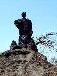 We started from Borivali at 6:30am
& reach the Village by 8:30am. Had breakfast at Kasar village which
is 2 km. further towards the Wada Side since there is no hotel at
Vagote village having 25 huts all together with one school. We started
our trek at 9:00am and reached on the top 12:30pm with sufficiant
break. There is no drinkable water scarcity, which was quite releif for
us in the summer. The route from Vagote passes through 2 beautiful
lake. The first lake is of Heart shape while the other one is on the
upper part near shirote village. We spent some time on the way in the
thorny bushes for good. I mean in the summer one can find the "Karvand"
a sweet dark marble size fruits. So we tried our luck to find Karvanda
whenever we saw the tree on the way. Its quite refreshing to have this
specially while on trek. We went to the col which crosses from the
Vagote side to the other side of the mountain ridge which descent
towards Gorhe village in one and half hr. This col has small pinnacle
on the left edge. We took right side route to enter the shady forest
where one can find the fort entrance totally in the ruined state. One
has to be watchful to find the wall, else one can overlook the little
portion easily. On top there is no shade as such on the leftmost side
keeping the main hillock on the right one can seee 9 water cisterns
& on the left 2 cisterens with no wter now days. Another 10 Min
walk towards the main hillock we entered in the Fort entrance wher one
can see little fortification & in the last water cistern out of 3
there exist potable water. We started from Borivali at 6:30am
& reach the Village by 8:30am. Had breakfast at Kasar village which
is 2 km. further towards the Wada Side since there is no hotel at
Vagote village having 25 huts all together with one school. We started
our trek at 9:00am and reached on the top 12:30pm with sufficiant
break. There is no drinkable water scarcity, which was quite releif for
us in the summer. The route from Vagote passes through 2 beautiful
lake. The first lake is of Heart shape while the other one is on the
upper part near shirote village. We spent some time on the way in the
thorny bushes for good. I mean in the summer one can find the "Karvand"
a sweet dark marble size fruits. So we tried our luck to find Karvanda
whenever we saw the tree on the way. Its quite refreshing to have this
specially while on trek. We went to the col which crosses from the
Vagote side to the other side of the mountain ridge which descent
towards Gorhe village in one and half hr. This col has small pinnacle
on the left edge. We took right side route to enter the shady forest
where one can find the fort entrance totally in the ruined state. One
has to be watchful to find the wall, else one can overlook the little
portion easily. On top there is no shade as such on the leftmost side
keeping the main hillock on the right one can seee 9 water cisterns
& on the left 2 cisterens with no wter now days. Another 10 Min
walk towards the main hillock we entered in the Fort entrance wher one
can see little fortification & in the last water cistern out of 3
there exist potable water.We had our Luch break at this point and after some rest we moved further to the topmost point of the fort where unique man like shape exist along with another small pinnacle. There are 2 small temples on the way one is of God Hanuman & other one is of Shiva. One can see the seperated Naganath Lingi from the top towards the Vagote village side. From the top the refreshing breeze made us relaxed for some time. From the South one can seee the Kamandurg, Towards North Asherigadh. We started our returned journey at arounfd 3pm. We reached the Upper lake in Next 2 hrs. We spent some time in the Lake & return back to our base. It was an enjoyable trek even in this season. In the rain it might be a paradise. Written By Rajan Rikame |
|
|
|
|