|
|
 |
|
|
| Date:
11-12 Sept. 1999
This sheer
cliff is a well-known land mark, very clearly visible from the Konkan
The walls of this pass jut-out from the main range and
hence command a magnificent view of the great bend in the Sahyadri. To
the north; one can have a view of Kalsubai, to the south Bhimashankar,
to the northwest is Harishchandragad across the Konkan plains, with its
cleft shattered pinnacles. To southwest; behind Siddhagad, are
seen the level tops of Matheran, the grate comb-like rock of Chanderi
& pinnacles of Haji Malang are also visible. This is a
pass which, once in history, enjoyed prime importance. At the Nane
Ghat, the encryption steps, rock cut rest houses, cisterns show that as
far back as the 1st century BC, this route was frequently used. Even
now, it carries heavy trade traffic. From Ghatghar, which is the last
road head from Junnar, One has to walk 6KM to reach the pass.
Good water & caves with excellent views. A broad route gently
leads down to the Konkan, & then a flat walk to Vaishakhare
and Tokavade(14km). (From: Trek the Sahyadris book of
Harish Kapadia) |
| |
|
|
| Date:
8-10 Nov 1999
This might be my seventh visit to Naneghat but this time my aim was to complete the long awaited trek of Jivdhan fort. I tried previously the same trek but due to unavoidable circumstances I could not complete it. 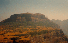 |
| |
|
Date: 21 July 2002 For Adventure Lovers, Trek to Naneghat via Bhorand Nala is a kind of eco- challenge. One can trek Naneghat by normal route & descend down to Moroshi village via Bhorand Nala or vice-versa. Ideal way out is the previous one which one can enjoy more. Especially in the Monsoon it is too good infact any Sahyadri mountain looks fresh & beautiful. You can feel the lower rain clouds. You will really enjoy the rain. One can forget his/her botheration /tension which a person accumulate day by day in our daily fast moving life. You can feel like you are part of this nature for some time. All your trek tiredness will run away like anything. Especially when you are at the top (Nana's thumb), the scene is too beautiful but little dangerous too. One has to take proper precaution especially in the rain. The Thumb shape rock is completely covered with rain clouds, you cannot see beyond five feet of range. If the clouds open you can see a sudden 800ft down deep konkan plateau towards Kalyan side(North). Sometime you may feel like you are watching the plateau through a small window of a gallery. The bhorand Nala is at backside, towards left of Ghatghar village while moving from Naneghat just 500mt. from the Ghat. A narrow gully descends down almost 600 ft. Then one has to take left route from a small nala, the other one(right) goes to the village. The right side route actually one needs to find out the way, takes you to the Kalyan-Malshej road near to the bridge. While descending down one can find so many waterfalls, rock walls, dense forest at the base. For us it took one hr. to trek from Nanegaht fata till the Naneghat caves & 3 hrs to descend via the Nala. I thought our new venture were successful by exploring this new route but a very bad seen at the end near the bridge at Fangne village. Two groups were having their liquor at two different places. Some of them couldn't able to walk near roadside. One of them fails down on the slippery rock plane near the bank & broke the bottle since lost his control. The other group left their un disposable plates near the bank with food remains scattered on the bank. One of the group while returning, the way they were driving, it was no good way. My mind started comparing the one group of school children (around 150 in nos.) they trekked the ghat in one Hrs. with plenty of energy & cheer. And at the backside all these young people doing unlawful activity & don't even know where they are. One of the drunken fellow were asking his another drunken fellow "from where these people are coming! Can we go?" There was no way to explain this people in this situation except our gesture (/body language) that we are not accepting you. I consider this article should put some light if it is effective. Finally Nature is giving us such beautiful things & in return we should consider it's our duty to keep the nature as clean as possible. |
| |
7th Oct 2012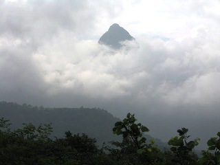 Trek to Siddhagadwadi Trek to Siddhagadwadi Moving back to India was not as much a challenge as finding some like minded and enthusiastic people who are into hiking, trekking, climbing, cycling or just running. With a billion plus population we are still a nation that enjoys nature from a distance. My search took me to the site of Bhramanti (http://www.bhramanti.com) and after some navigation around the site I sent a couple of mails to the site admin and Rajan Rikame. Then it was all waiting. Then one morning I got a mail
from Kiran Sarode. It was about the hike to Siddhagad Fort. Cut short
and soon I was waiting at the bus stop near SEEPZ on JVLR at 5:30 AM.
It's a real man soon (monsoon) these days in Mumbai & All over Maharashtra. The day Chief Minister declared draught area in Maharashtra due to no rain; the next day rain started continuously till today. Add-on to this the Maharashtra Govt. asked for a grant of Rs. 1000 Caror for the draught relief to the Canter. Now most of the Mumbaities must be thinking that the amount proposed to get for the relief may be utilised for the flood relief, such a heavy rainfall!!! If you forget all these botheration & decide to enjoy the day there is no way better that to go for a trek in the Sahyadri range of mountains. Offcourse there should be some exception like many people wants to get relaxed at home watching TV & sipping Tea but in the polluted Mumbai's air, some may want to see movies along with the friends once again in the polluted air, etc etc. So as per me or like minded people monsoon trek will be ideal way out to spend your weekend which will give you something better than described before. You will get atleast next 2-3 days of freshness feelings, sense of achievement, you will know your limits & level of cooperation. For nature lovers; they will hear & see various colourful birds which makes the nature more beautiful. For photography; sky is the limit if one can see in the monsoon. Siddhagad is a fort in the Murbad/Kalyan region. You need to reach Narivli either by local State transport bus which starts from Murbad or by any other vehicle. It's better to reach early around 7-8am & start the trek. It's a well known square massif, standing very prominently away from the main range. Facing towards Siddhagadh on the left one can see Gorakshgadh & Maschindragadh. One can reach the fort from Kotwal Smarak. Two freedom fighters (Bhai Kotwal & Hiraji Patil) was shot dead at this place by Britisher on 2nd Jan 1943. In my mind I thought this trek will be a kind of tribute to those freedom fighter on the nearest eve of the 55th Independence day (15th Aug 2002). The trek was organised by Sahyagiri, we were 16 in number. Due to heavy rainfall though we could not able to reach the balekilla but we enjoyed the rain very well & had lunch at Narmata Temple which is at the base of the fort. The temple is ancient & in the verge of getting no trace of all well carved idols & all. We did little survey around the temple. We had re-established a pillar stone which was rolled down on the main route from the temple. After lunch & little rest in the Temple premises we started our returned trek journey from another safer route than the one which we took while ascending. On the way while crossing the ghat little we had been to a place little above the pass where a broken canon exist & which was supposed to be a point from where the canon attack has to happened. On the other side of the point one can find the deccan plateau mountain range & down the konkan area towards Murbad. The sudden clearance of the fog gave us a clear view of the mountain range on the left side which was supposed to be Goraksh/Maschindra range. While returning from the route towards Kotwal Smarak needs to find out which is along the running stream While
returning I found one of the local guide putting the rappers of the
toffee in his pocket which I suppose a very nice part of this trek. I
hope if such kind of awareness happens everywhere then definitely such
places will remain intact & clean. |
|
|
|
|
|
|
 who traveled together
towards Murbad in 3 vehicles. We stopped by at Mhasa and has a small
breakfast of Misal Paao, a spicy local food with bread.
who traveled together
towards Murbad in 3 vehicles. We stopped by at Mhasa and has a small
breakfast of Misal Paao, a spicy local food with bread. We had a
short break and pushed for the fort. We crossed the stream as the
bridge had its approaches completely taken over by greenery and we did
not want to part of a snake dance or rush one of us to some doctor. The
day was getting hotter and I was in a misery. I really need to get my
brown skin readjusted to the heat in India if I want to enjoy the
nature here. Carry a lot of water and electrolytes. You will need them
here. I have still to find out the kind of clothes one needs but
synthetics do work well as humidity is prevalent in these regions for
most of the year. But summers are dry and one would need to be more in
cottons.
We had a
short break and pushed for the fort. We crossed the stream as the
bridge had its approaches completely taken over by greenery and we did
not want to part of a snake dance or rush one of us to some doctor. The
day was getting hotter and I was in a misery. I really need to get my
brown skin readjusted to the heat in India if I want to enjoy the
nature here. Carry a lot of water and electrolytes. You will need them
here. I have still to find out the kind of clothes one needs but
synthetics do work well as humidity is prevalent in these regions for
most of the year. But summers are dry and one would need to be more in
cottons.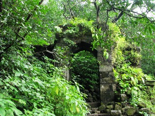 J&K in 1976. A
real veteran and my respects for him.
J&K in 1976. A
real veteran and my respects for him.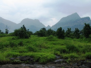 Indra
blessed us with a little shower and we headed back out. Unlike other
hikes, coming down from the Siddhagarh Fort was a challenge in itself.
The slippery terrain was not easy and the little rain had decided to go
down with us too. The streams were fuller but we made down to the
Narivali village in good time before the sun set.
Indra
blessed us with a little shower and we headed back out. Unlike other
hikes, coming down from the Siddhagarh Fort was a challenge in itself.
The slippery terrain was not easy and the little rain had decided to go
down with us too. The streams were fuller but we made down to the
Narivali village in good time before the sun set.