|
|
|
|
|
|
| View Larger Map Date: 24-26 Jan 2003 The Bhramanti group, a few guests and a few new comers, all gathered at Mumbai CST at 11pm on Friday, 24th January 2003. We caught the last train to Karjat at 12.45am. A few participants boarded the train at Dadar and a few met us directly at Kalyan. We reached Kalyan at 2.15am and spent the remaining night at the ST depot. In all we were 17 and our group leader was Rajan, a very experienced trekker. We were also lucky to have other experienced trekkers like Milind, Deepak, Dharmesh. We caught the first bus at 5.30am, but had to disembark because a few participants arrived late. We finally caught the 6am bus. The ride was very scenic and the driver was very fast. We could see the beautiful hills, peaks and forts of the Malshej Ghat region. Just before reaching Malshej there is a tunnel, resembling the one on the Khandala Ghat. A Malshej we saw the Flamingo Hill Resort at the edge of the ghats. We finally got down at Khubi phata at 9am, about 92kms. from Kalyan. This is not an official ST stop, but one can request the conductor to halt the bus here. 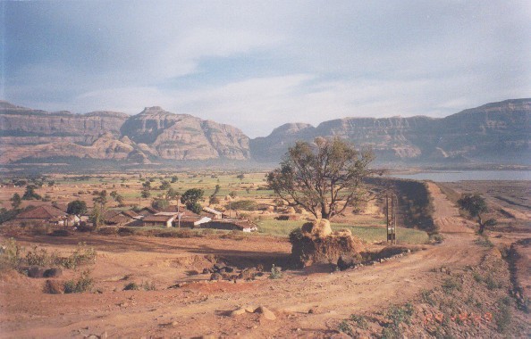 We
had breakfast
prepared by one of the member Reshma and tea at the roadside tea-stall.
To our good luck we got an empty tempo going to Khireshwar, the base
village
of Harishchandragad, 5kms. away. The tempo journey made everybody
remembered
recent Favicol add. This saved us an hour of walking. There is a
beautiful
lake all along the road. In fact the road is built on the dam. We
had breakfast
prepared by one of the member Reshma and tea at the roadside tea-stall.
To our good luck we got an empty tempo going to Khireshwar, the base
village
of Harishchandragad, 5kms. away. The tempo journey made everybody
remembered
recent Favicol add. This saved us an hour of walking. There is a
beautiful
lake all along the road. In fact the road is built on the dam.
At Khireshwar we had an introduction and a brief talk by our leader. We decided to take the Tolar Khind route to our destination, Harishchandragad. After a 15 minutes walk two routes bifurcate. A few who were ahead took the easier route on the right and the few lagging behind took the route on the left. This route require a bit of rock-climbing. Both the route eventually meet in the forest just before a small water tank. Finally, the entire group met at Tolar Khind. We took a bit of rest and turn left to Harishchandragad as indicated by arrows. The route straight ahead goes to Kothale village. The entire route from the base village to the fort is marked with red and white arrows, so it is very easy to locate the route. After a tricky climb we reach the plateau of the fort. From here after crossing 7 humps we finally reach the fort at 2.30pm. We quickly occupy 2 caves in the Harishchandreshwar Mahadev temple complex, a beautiful temple carved from solid black rock. After lunch and a bit of rest we proceed to Konkan Kada at 5pm. This is a unique formation in the Sahyadri and the best part of the fort. It is a semicircular cliff of about 2000 feet straight drop in the Konkan plains. The grandeur and beauty of the plains and the surrounding mountains leaves us totally spellbound. It is such a fascinating site that a boy from Pune jumped off this cliff few years ago. A monument is built in his memory which no longer exists. One of our friend from other group known to Rajan told the other way(Jokingly) that the monument place is waiting for another one to fill in. One cannot imagine this if one had a look in the deep valley of Konkan Kada. We sit and wait for sunset as it is one of the best sunsets in the Sahyadri's We saw a small peice of Rainbow on either side of the sun one after another. As the sun was setting, it lit up the cloudes with strokes of different colours. While waiting for few others from our group; on request, Rajan had brief intro of Taichi art to Nayan & Ravi. At 7pm, after viewing the beautiful sunset we proceed back to the temple with the help of our torches. We then prepare our dinner with the help of a stove and utensils. Their were total 14 Chef/cook all together. After dinner we knock- off by 10pm. It was a wonderful experience sleeping in caves. The next day on Republic day, we got up at 7am and after freshening up we proceed to Taramati peak, the highest point of the fort at 4671 feet. It is an easy half hour climb uphill. There is a small Shivling on Taramati. From here in the north we get a very good view of Igatpuri range of mountains and the highest peak of the Sahyadris, Kalsubai at 5400 feet. In the south we can see the Malshej road, Nane- Ghat. After a few group photographes, we come back to our cave and have our breakfast. We then decide to take the Junnar darwaja route to Khireshwar via 'Kalshaya col'. Since the route was unknown to us we hire a villager who runs a small dhaba on the fort. We finally start our trek at 11am. After crossing a hump we start descending. After sometime we come across a gully which descends steeply down. It is known as 'Wat' in Marathi. This route is the ancient route and there are steps which are in very bad condition. At the side there are niches in the wall for gripping. After 2 hours of descending we turn left in the forest and finally we reach Khireshwar at 5pm. After having water we walk back to Khubi phata. We have tea here and wait for a ST bus. No ST bus stopped here because they were full. We decide to hire a tempo. The tempo was full of goonies of onions and we had to sit over them. We sang songs and enjoyed ourselves. Even though the tempo was going to Kalyan, the driver agreed to take us to Murbad, 29kms. short of Kalyan. We reached Murbad at 9.30pm from where we hired a Trax to Kalyan station. This was indeed a memorable trek for all of us and I hope to see you in the future. Written by: Ruzbeh Billimoria. Last
visit Date: 23-25 June 2000 |
|
|
|
|